Celestial Coordinate Systems
Celestial Coordinates are used to define the position of an astronomical object. The various coordinate systems allow a position to be determined with respect to specific vantage points. The three most commonly used systems are refered to as the AltAzimuth, Equitorial and Ecliptic systems.
The AltAzimuth system uses, as it’s fundamental plane, the plane tangential to the Earth’s surface at the observer’s position. The coordinates are termed Altitude & Azimuth.
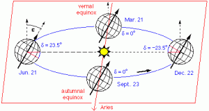
The Equitorial system uses, as it’s fundamental plane, the plane which passes through the centre of the Earth and the Earth’s Equator.The coordinates are termed Declination & Right Ascension.
The Ecliptic system uses, as it’s fundamental plane, the plane which passes through the centre of the Sun and the path of the Earth (and thereby roughly the solar system planets in orbit) around the Sun.The coordinates are termed Ecliptic Latitude & Ecliptic Longitude.
The following diagrams illustrate these coordinate systems. A good, fuller description can be found on the Wikipedia page Celestial coordinate system.